 Located really close to Ushuaia, Martial Glacier provides the views of a lifetime. You need a bit of stamina to tackle the hike, but in the end, it’s surely worth it.
How to get to Martial Glacier
Follow the national route 3 about 7 km out of the town of Ushuaia. The road is paved and signaled. Once arrived at the base of the mountain, there’s a ski slope. Take the ski lift up the slope and now you can see the glacier on one side and the Beagle Channel on the other. If you want to get closer to the glacier, you need to hike for another 2 km.
Gear and fitness
During the summer, the entire mountain is ideal for hiking long or small distances. You can either hike up or take the ski lift, but make sure to take the decision based on your fitness level. There’s no point in trying the impossible if you know you cannot hike in such conditions. And remember, you do need good trekking boots if you want to hike the trail.
If you want to climb up on the glacier you need both the gear for ice climbing and the experience to do so. However, the walk on ice is quite easy. The steepest part is at the bottom of the trail. During spring and winter you should be extra careful as the ice bridges are at their weakest.
In case you don’t have ice climbing gear, you can climb the Black Canyon on the wide valley which is to the right of the ski lift.
Panorama
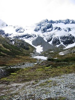
If you can get to the highest point you can see a lovely panorama of the mountains on Hoste island, with its glaciers and the Beagle Channel.
Before starting the climb up the glacier, make sure to watch the lovely panorama which unfolds under your eyes: the valley of Andorra, mount Vinciguerra and Vinciguerra glacier.
Skiing
During the winter, the mountain turns into a ski resort, although with only one ski slope.
Other hiking trails
The Martial Glacier is not the only lovely track near Ushuaia. Here is a list of them:
- Pampa Alta Track is of medium difficulty and is 9 km long. Once at the top you can see lovely views of the Beagle Channel.
- Coastal Track is another medium track, 6.5 km long (one way), which follows the edge of the Ensenada and Lapataia bays.
- Guanaco Peak Track is a high difficulty trail of only 4 km and leads up to the Guanaco peak.
- Island Walk is one of the easiest tracks and is only 3 km round trip along the banks of Lapataia and Ovando rivers. This is the ideal track for bird watching.