Categories
Transportation

Getting from San Francisco to Santa Barbara (and return)

San Francisco is an important city in California, famous for architecture, scenic beauty and the cultural and ethnic diversity. The Golden Gate is a landmark recognized all over the world.

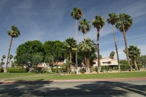
Santa Barbara is perfect for a day trip from Los Angeles , but is also an excellent side trip for those visiting the entire state of California. It is well known for its beaches, shopping options and wineries.

Quick summary

The cheapest option for traveling between San Francisco and Santa Barbara is by bus. Single fares start at $57.15* and the journey takes about 9 h.

There isn’t a direct rail link between the two cities, so you need to go via Oakland (for the shortest route) and travel by bus and then by train. The fare is almost double than the bus fare.

Flights are excluded as option as there is only one carrier operating on the route and the fares are very high.

Flights from San Francisco (airport code: SFO) to Santa Barbara

San Francisco International (SFO) is one of the largest airports in the world and handles both international and domestic travel.

Santa Barbara is served by Santa Barbara Municipal Airport (SBA), which handles about 30 daily flights to/from US cities. Flights from San Francisco are operated only by United Express. The flight time is 1h 20 min.

Direct single fares start at $400 one way in late December 2011 and mid-March 2012. Indirect flights start at $120 one way.

Trains and buses from San Francisco to Santa Barbara

Amtrack offers connections for only part of the route between the two cities, as San Francisco is not served by a train station. So you need to take the bus and the train to travel from San Francisco to Santa Barbara.

There are two possible routes to choose from:

Route 1:

Step 1: San Francisco Caltrain Station to Oakland Jack London Square by bus

The bus leaves San Francisco at 7 a.m. The layover time is 25 min

Step 2: Oakland to Santa Barbara by train

The train leaves Oakland at 8:50 a.m.

The total travel time (excluding the layover) is 10 h 52 min. The single adult fare is $96.

Route 2:

Step 1 : San Francisco Caltrain Station to Emeryville, CA by bus

The bus leaves San Francisco at 8:45 a.m. The layover time in Emeryville is 10 min.

Step 2 : Emeryville, CA to Bakersfield, CA by train

The train leaves Emeryville at 10:15 a.m. The layover time in Bakersfield is 9 min.

Step 3 : Bakersfield, CA to Santa Barbara by bus

The bus leaves Bakersfield at 4:20 p.m.

The total travel time (excluding layovers) is 10 h 29 min. The single adult fare is $96.

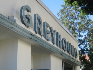
Buses from San Francisco to Santa Barbara

Greyhound operates three direct buses per day between San Francisco and Santa Barbara. The travel time is between 8 h 40 min and 9 h 5 min. The web only single adult fare is $57.15.

The buses leave San Francisco at: 5:20 a.m., 10:30 a.m. and 9 p.m. The only direct bus leaves Santa Barbara at 8:55 a.m. and takes 9 h 20 min to get to San Francisco. Three other indirect buses (via Oakland and San Jose, respectively) leave during the day. Regardless of the route chose, the same fares as above apply.

Driving from San Francisco to Santa Barbara

You can rent a car and drive the 337 miles between San Francisco and Santa Barbara on US-101 S. You should be able to cover the distance in 5 h 45 min but do make sure to plan some stops along the way.

View Larger Map

Note: *at the time the article was written

Photo credit

Categories
Transportation

Getting from San Diego to Palm Springs (and return)

San Diego is the second largest city in California and is well known for the excellent weather, beaches, the famous Zoo and quick access to the Mexican border and Tijuana. San Diego offers a lovely escape from the hustle and bustle of Los Angles .

Palm Springs is a resort city in California and offers a lot of indoor and outdoor activities. You can spend the day hiking or trying other outdoor activities and relax in the evening.

Quick summary

There isn’t any direct route to travel between San Diego and Palm Springs, unless you plan to drive. The cheapest option for traveling between San Diego and Palm Springs is the bus. Single tickets cost $31.50* and the travel time is up to 5h. Train tickets are more expensive and the connection is via Los Angeles. Flights aren’t even an option due to the very expensive fares for the Los Angles to Palm Springs leg of the trip.

Flights from San Diego (airport code: SAN) to Palm Springs

There aren’t any direct flights from San Diego to Palm Springs, but you can fly via Los Angles, which makes it a very expensive journey.

For the first leg of the trip, book a flight between San Diego and LAX. San Diego International Airport (SAN) is located 3 miles from the central business district of San Diego and is the second busiest single runway airport in the world (after London Gatwick). It is a focus city for Southwest Airlines. Flights to LAX are operated by: American Eagle, Delta Connections and United Express. The flight time is 40 minutes. In late December 2011 and mid-March 2011, expect to pay from $119 one way on United.

For the second leg of the trip, book a flight from LAX to Palm Springs, which is served by Palm Springs International Airport (PSP). Flights between LAX and Palm Springs are operated only by United Express. In late December 2011 and mid-March 2012, expect to pay from $511 for the 51 minutes flight. Indirect flights start at $211 one way.

>>read more about Flights to Los Angeles

Trains from San Diego to Palm Springs

Amtrak offers train connections between San Diego and Palm Springs via Los Angles. The total journey time is 6h 45 min and the single adult fare is $83.

The train leaves San Diego daily at 10:50 a.m. and arrives in Los Angeles at 1:35 p.m. Another train leaves for Palm Springs at 3 p.m.

The train leaves Palm Springs daily at 4:45 a.m. and arrives in Los Angeles at 8:30 a.m. Another train leaves for San Diego at 9:40 a.m.

Buses from San Diego to Palm Springs

Greyhound offers bus connections between San Diego and Palm Springs but this is not a direct service either. Buses go either through San Bernardino or Riverside.

The travel time is 4h 25 min (via San Bernardino) and 4 h 50 min (via Riverside) and the web only single adult ticket is $31.50 regardless of which route you choose. Buses depart San Diego at 10:45 a.m. and 4:10 p.m. Buses depart Palm Springs at 11:05 a.m. and 5:45 p.m.

Driving from San Diego to Palm Springs

When you rent a car and plan to drive from San Diego to Palm Springs , there are three possible routes to choose from. The on highlighted in the map below is via I-15 N and CA-74 E. The 133 miles can be covered in about 2h 40 min.

View Larger Map

Note: *at the time the article was written

Photo credit

Categories
Los Angeles Transportation

Getting from Los Angeles to Santa Barbara (and return)

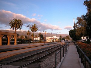
“Riviera of the West” or Santa Barbara is perfect for a day trip from Los Angeles . Located about 100 miles from the City of Angels, Santa Barbara is well known for its beaches, wineries and the many shopping options. You might know it to be the playground of the rich and famous, but don’t worry, a day or two here won’t break your budget.

Quick summary

If you choose the afternoon train between Los Angles and Santa Barbara, then that’s the cheapest option: $16* one way. Otherwise, buses remain the most affordable way to travel between the two cities ($19.35 one way).

Flights from Los Angeles (airport code: LAX) to Santa Barbara

Although LAX is the closest large airport to Santa Barbara, the city is served by its own airport Santa Barbara Municipal Airport (SBA), which handles about 30 daily flights to/from US cities, including Los Angeles. The airport is located about 7 miles from downtown.

Flights to/from Los Angeles are operated by American Eagle and United Express. The flight time is 40 minutes. In late December 2011 or late March 2012, expect to pay from $91 one way on American Eagle or United Express.

>>read more about Flights to Los Angeles

Trains from Los Angeles to Santa Barbara

Amtrack provides eight daily connections between Los Angeles Union Station and Santa Barbara. The first train leaves Los Angles at 7:35 a.m. and the last at 9:10 p.m. The first train leaves Santa Barbara at 6:46 a.m. and the last at 6:59 p.m.

The travel time is 2h 25 min. The cheapest fares are in the afternoon: just $16 for a single adult ticket. On the morning train, the fares start at $36 one way.

Buses from Los Angles to Santa Barbara

Greyhound offers four daily buses between Los Angles and Santa Barbara. The buses leave Los Angeles at : 6:10 a.m., 1:25 p.m., 6:10 p.m. and 10:20 p.m. Buses leave Santa Barbara at 6 a.m., 9:30 a.m. 2:45 p.m. and 8:10 p.m. The journey time is between 2h 10 min and 2h 40 min. The web only single adult fare is $19.35.

Driving from Los Angeles to Santa Barbara

You can rent a car and drive the 95 miles via US-101 N between Los Angeles and Santa Barbara. Part of the road is along the coast, so you’ll be rewarded with superb views. The travel time is 1h 45 min.

View Larger Map

Note:*at the time the article was written

Photo credit

Categories
Planning a Trip Portugal Transportation travel guide

Getting from Lisbon to Porto (and return)

Lisbon is the capital of Portugal and has recently started to gain more and more popularity among travelers. It is one of the rare Western European cities which faces the water and knows how to use this for its own advantage. The intimate alleys, the superb views and the contemporary culture make it a travel destination year round.

Porto is the second largest city in the country. It is a busy industrial and commercial central. Its historical city has been awarded World Heritage status by UNESCO in 1996. The historical sites, along with the lovely scenery enchant any traveler.

Those planning a vacation in Portugal most often plan to visit both cities. So knowing how to get between them cheap and easy is a must.

Quick summary

Flying takes less than one hour, but for whatever reason, it’s cheaper to book a return flight between the two cities, rather than a one way flight. Still, for €132 per person you can travel between the Lisbon and Porto. A much better option is the train, which takes 3 hours and is also cheap (from €24 per person, one way).

Flights from Lisbon (airport code: LIS) to Porto

Aeroporto da Portela (airport code: LIS) serves Lisbon and is the largest international airport in Portugal. It is the main hub for TAP Portugal. Sá Carneiro Airport (airport code: OPO) serves Porto and is the 3rd largest airport in the country. The only airline running flights between Lisbon and Porto is TAP Portugal. The flight time is 55 min and the one way adult fare is €148. Return fares start at €132 per person.

>>read more about Cheap Flights to Lisbon

Trains from Lisbon to Porto

The national rail company (CP) offers direct trains from Lisbon to Porto. There are 18 departures daily and the travel time is 3 hours. The trains depart either from Lisboa – Entrecampos or Oriente. The 2nd class (turistica) fares start at €24 for an adult, one way. There are two types of trains to choose from: InterCity and Alfa-Pendular. Tickets can be bought here

>>read more about Train Travel in Portugal

Buses from Lisbon to Porto

Rede Expressos runs buses between Lisbon and Porto. Unfortunately, at the time this article was written neither versions (English or Portuguese) of the website allow us to check the timetable or the prices.
Other website which lists buses from various companies gave the price for the Rede bus: €16.50 for an adult, one way. The trail time is 3 h 30 min.

>>read more about Bus Travel in Portugal

Driving from Lisbon to Porto

Driving from Lisbon to Porto is a real pleasure and you’ll be rewarded with superb views. So, rent a car , get a map and plan your trip. The shortest route is 317 km and you should be able to cover it in 3 hours. Please note that you’ll have to pay tolls.

View Larger Map

Photo credit

Categories
Alaska Transportation

Direct International Flights to Anchorage

Millions of travelers from all over the world come to Alaska each year to experience the unique cultures, unspoiled wilderness and all of the other charms the state has to offer. The majority of those visitors coming from outside of the United States enter Alaska by way of an international flight to Seattle and then a shorter flight from Seattle to Anchorage. But depending on where you are coming from, there are several options for direct international flights right to Anchorage. Direct international flights are often cheaper, and are always faster, than having to book both an international and domestic flight.

Frankfurt is currently the only airport in Europe serving direct flights to Anchorage, and these flights are only available in the warmer seasons. Of any country, Japan has the most options for flying to Anchorage, with direct flights departing four different airports. Vancouver, British Columbia is currently the only airport in Canada with direct flights in, and there are none from Central or South America.

Currency exchange is available inside Ted Stevens Anchorage International Airport. For information on currency, plug conversion and other helpful hints on international travel to Alaska, check out our Alaska Information page.

International Routes to Anchorage

From the Americas

  • Vancouver, BC, Canada (on Air Canada, seasonal only)

From Asia

  • Fukuoka, Nagoya, Osaka, and Tokyo-Narita, Japan (Japan Air)
  • Taipei-Taiwan (China Airlines and EVA Air)
  • Seoul, South Korea (Korea Air, seasonal charter only)

From Europe

  • Frankfurt, Germany (Condor Air, seasonal only)

>> More on finding the right flight to Alaska

Categories
Alaska Transportation

Getting from Seattle to Anchorage

2780880072_9d3eff74b8
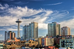
Alaska is one of two US states that doesn’t border any of the others directly, so it can be a long trip even for Americans. Because its the closest large American city to Alaska, Seattle is one of the most popular starting points for a trip to the frontier state. The two cities have a lot in common, both being coastal northwest cities with a population that likes to get outdoors and explore. Whether you are a Seattle resident or an international traveler stopping there on the way, there are several options for getting from Seattle to Anchorage. There are no rail options that cover the entire route, but trains can get you part of the way, if you want to make the cruise or drive to Anchorage a shorter one.

Flights from Seattle-Tacoma to Anchorage

This flight route is the single most popular way for outside visitors to get to Alaska. There are daily flights year-round on both Alaska Airlines and Continental Airlines from Seattle-Tacoma Airport to Ted Stevens International Airport in Anchorage. Flight time is about three hours, making this route the fastest option for getting from the lower 48 states to Anchorage. Flying is also usually the cheapest option. To search for flights, enter your travel dates into the form at the bottom of this page.

>> International travelers may be able to skip the stop in Seattle and get a direct international flight to Anchorage
>> More about flying to Alaska

Cruises from Seattle to Anchorage

If you aren’t in such a hurry, and want to see some of the amazing coastline between these two coastal cities, consider taking a cruise from Seattle to Anchorage. Though more travelers board their cruise in Vancouver rather than Seattle, starting in Seattle gives you more ship time, and includes views of the stunning Puget Sound as you depart. The major cruise trips all take about seven days, and ships range in size from the 235-passenger Empress of the North to the huge 2000+ passenger cruise ships from Princess, Royal Caribbean and other providers.

>> Find out more and search for cruises with our Alaska Cruise Guide.

Driving from Seattle to Anchorage

As close as Seattle is to Alaska, in comparison to the rest of the country, it’s still a good distance. Some might be surprised to learn that the driving distance between the two cities is 2,250 miles, about the same as between New York and Phoenix, Arizona. That being said, if you have the time to devote to this drive, it can be one of the most memorable and beautiful you will ever take. If time is no object, and you want to see and interact with both Alaska and British Columbia, this is the way to go. The drive at least five days for a quick trip, and seven if you want to make stops and wander a bit, so it’s really no faster than a cruise.

Photo by bensonkua

Categories
Alaska Transportation

Getting From Anchorage to Fairbanks (and back)

3857293492_a41ef086b9
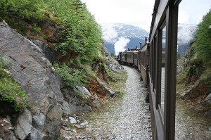
Being the two biggest cities in Alaska, Anchorage and Fairbanks are on the itineraries of many visitors to Alaska, and there are several options for traveling between the two cities. Which one is right for you depends on your budget, your style of travel, and how much time you have to spend.

Flights between Anchorage and Fairbanks

By far the fastest way to get between Anchorage and Fairbanks is by plane. This is also sometimes the only way to make the trip during the winter months, when roads are closed and trains aren’t operating. There are multiple flights daily on Alaska Airlines, and flight time is about an hour. To search for flights, use the form in the right column of this page.

Trains between Anchorage and Fairbanks

Alaska Railroad runs daily service (in the summer months) between the two cities. The trip lasts about 12 hours, and passes through some of the most beautiful countryside in Alaska, including stops at Talkeetna and Denali National Park. If you don’t mind dedicating a day of your trip to this leg, the views are spectacular, and there are always great conversations to be had with your fellow passengers as you watch out the windows for wildlife and scenic vistas. For those travelers looking for more than a simple train ride, there is the Princess Tours Midnight Sun Express, a full-service luxury train with a domed glass ceiling for the best possible views, and onboard fine dining options.

Driving from Anchorage to Fairbanks

As nice as a glass-domed train ride might be, you still can’t stop and choose your own speed on the train, and so some travelers prefer to drive themselves. The only road option is the George Parks Highway, or Alaska Route 3. The 358-mile trip takes about 7 hours, not including stops, and you will want to make stops, since the road passes through not only Denali National Park, but also less well-known spots like Eklutna Lake. Plan on a full day for making this trip – keeping in mind that a full day in the summer can last quite a while. For those wanting to make it more than a day’s trip and stop in the middle, Talkeetna is close to the halfway point and offers a very different kind of Alaskan experience than either of the cities.

Photo by lisahazen

Categories
Los Angeles Transportation

Getting from Los Angeles to the Grand Canyon

grandcanyon
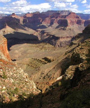
As two of the certain must-visit places in the US, Los Angeles and the Grand Canyon are easily combined in one trip, but getting from one to the other isn’t quite as straightforward as you might expect. There is a small airport at the Grand Canyon, but there aren’t scheduled flights from major airlines, so it can be a little tricky unless you know how to pull this off.

For the purposes of this article, we’ll be discussing the South Rim of the Grand Canyon, as this is where the vast majority of the tourist infrastructure and famous views can be found. The North Rim is actually a long drive from the South Rim, and it’s much harder to reach from Los Angeles as well. The South Rim is a far better place to visit for first-timers as well, so forget the North Rim for now.

Los Angeles to Grand Canyon

  • Distance apart: 410 miles / 660 kilometers
  • Driving distance: 502 miles / 808 kilometers

Quick summary

Unless you intend to actually spend some time in either Phoenix or Las Vegas, which isn’t a bad idea now that we mention it, then driving to the Grand Canyon is probably the best bet for most people. You can also fly to one of three airports or take a train or bus, but all of those options won’t get you all the way there.

Flights from Los Angeles to the Grand Canyon

This is where it gets complicated. There is a small airport near the Grand Canyon, but it only does charter flights, mostly out of Las Vegas and for aerial tours of the area. This means if you are intent to fly you have 3 options.

Fly into Flagstaff, Arizona (FLG) – This small airport is about 90 miles south of the South Rim, and has a few regular flights that have surprisingly low fares if you book in advance. There’s a bus company called Open Road Tours and they have regular coaches to the Grand Canyon from Flagstaff.

Fly into Phoenix, Arizona (PHX) – This is a huge city and airport about 240 miles south of the South Rim. From here you can rent a car cheaply and it’s a lovely drive as well.

Fly into Las Vegas, Nevada (LAS) – This growing city is about 280 miles from the South Rim, and a bit less to the North Rim. Rental cars tend to be cheap, but then again the drive itself isn’t much farther than driving all the way from Los Angeles.

Trains from Los Angeles to the Grand Canyon

You can’t take a train all the way to the Grand Canyon, but you can take it directly to Flagstaff, which is only about 90 miles away. From there you can take the Open Road Tours bus to the Grand Canyon. One tricky thing is the trains usually leave in the evening, so you arrive in Flagstaff the next morning.

Journey time: About 10 hours
Typical price: About $59 each way
>>Amtrak site

Buses from Los Angeles to the Grand Canyon

The bus situation is exactly like the train situation, mentioned above. You can take a Greyhound bus to Flagstaff and then the Open Road Tours bus from there. It’s a bit slower, and even a bit more expensive than the train, but at least you have the option of traveling during the day.

Journey time: About 12 hours to Flagstaff
Typical price: $64 one-way if you buy online in advance, and up to $85 if you buy on the day.
>>Greyhound website

Driving from Los Angeles to the Grand Canyon

This might be your best bet, since all the other methods are complicated and indirect anyway. You can get specific directions on any online map site, but the quick version is you find your way to I-40 out of Los Angeles, and then drive about 420 miles to Williams, Arizona, at which point you’ll take AZ-64 north for about 70 miles and you are there.

Journey time: About 8 hours

Categories
Los Angeles Transportation

Getting from Los Angeles to popular tourist cities explained

carjump1As someone who grew up in Los Angeles, it’s easy to forget just how complicated the transportation city can be. When I am planning a trip to another city for the first time I have been known to spend a lot of time researching exactly the best way of getting from one place to another, and it can often be far more complicated than you’d think.

You may have already noticed that we’ve been working on this series for a while now, and we’ll keep it going adding new places regularly. The main things we are trying to help people sort out is when is it best to fly or to take the bus, or drive, or is there even train service available? Some of these things aren’t nearly as straightforward as you would guess.

On each of these articles we not only discuss how long each method takes, but also the typical price of each method. Many places on the internet seem reticent to quote prices, for fear that they’ll quickly be out of date, but most of these things are fairly stable, and even if the prices go up by 5 or 10% next year, having this information should still be enough to help you determine which strategy works best for you.

Getting from Los Angeles to…

Anaheim

When most people are planning their first-ever trip here, they at least want to know how they’d get to Disneyland, even if they don’t actually go through with it. The fact is that getting from LA to Anaheim is somewhat complicated and time consuming unless you’ve got a car, but of course this is Los Angeles and you really should rent a car if you can. There are buses and even trains that will help, though they aren’t fast or cheap, which really sucks considering how close Disneyland is to most of Los Angeles.

San Diego

This is kind of similar to Anaheim in that you’d think there would be a variety of cheap and relatively easy ways of getting from LA to San Diego, but again the best method by far is by car. There are buses and trains, but both of them tend to be slow and complicated, and not all that cheap either. You would never want to fly between these two cities, as they are just close enough that it would actually take way longer dealing with all the airport stuff than any of the other methods available.

San Francisco

This one is far more straightforward. Getting from LA to San Francisco is usually done by air, and cheap flights are usually available if you book a bit in advance. There’s also a train, and even though it’s kind of slow and expensive, it’s actually a great ride with incredible scenery. You can of course drive or take a bus, and at least you don’t waste a lot of time making connections on this route.

Las Vegas

This is similar to San Francisco, except with no train option. Getting from LA to Las Vegas is usually done by air as well, and flights can be crazy cheap if there is a promotion on. Driving takes about 5 hours each way, or a bit less if there is no traffic. There are buses, but you really don’t want to take them unless you have to.

Phoenix

Here’s another nearby city with a similar situation, except we add a complicated train trip in as another choice. Getting from LA to Phoenix is very easy by air, and there are nonstop flights leaving every few minutes from one of LA’s five major airports. But if you want to drive yourself it’s a rather nice journey. There are cheap buses, and even trains that will get you fairly close.

Grand Canyon

This one is tricky since there is no proper airport near the canyon itself. Getting from LA to the Grand Canyon means getting to Flagstaff, Arizona, one way or another, and then driving or taking a shuttle bus from there. The instructions are all here, and driving the whole way may be your best option.

New York

This one is obvious, but still there are quite a few people from abroad who wonder if there are trains or buses running between these huge coastal cities. Well, there are, so getting from LA to NYC has plenty of choices involved. Flying is surprisingly cheap most of the time, but one of the land-based methods can make for an unforgettable trip (but avoid the buses).

Categories
Los Angeles Transportation

Getting from Los Angeles to Phoenix

phoenixfreeway
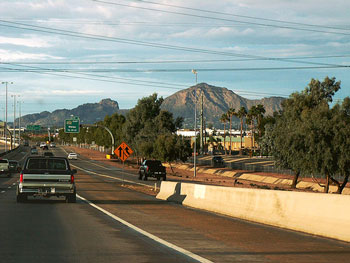
Especially as the December holidays approach, more and more people start thinking about spending a bit of time in Phoenix, Arizona. Depending on where you are from it could seem like paradise there during the winter months, or like a waste of time. Plenty of people from Los Angeles make the trip each winter, and fortunately there are several decent options available for getting there. Let’s go over them below, shall we?

  • Miles apart: 364 miles / 586 kilometers
  • Driving distance: 372 miles / 599 kilometers

Quick summary

It’s actually quite a nice drive the first few times you take it, and the road is about as straight as can be, so you’ll get there fast. But still, there are usually great deals on flights to Phoenix so that’s the way to go for most people. You can often rent a car there cheaply as well, and save the wear and tear on your own wreck. Buses are cheap, but take a long time, and there is a way to get there on the train, sort of.

Flights between Los Angeles and Phoenix

Unless you love driving, this is probably the best way to go for most people. Quite a few airlines connect these cities nonstop, and US Airways (at least the former America West part of it) has a very busy hub at Phoenix Sky Harbor (PHX) Airport, so there are cheap flights nearly every hour of the day. You can often get great deals out of any of the 5 major Los Angeles area airports, with prices starting around $60 each way if you buy in advance.

Flight time: 1 hour 15 minutes
Typical one-way fare: Starting at $60

Trains between Los Angeles and Phoenix

There used to be a train that went directly between these two cities, but lately the Amtrak service can only get you close. You can take the train that goes to Chicago and get off in Flagstaff, Arizona, but that takes 10 hours and then you have to take a bus from there to Phoenix, which adds another 3 hours or so. You can also take a train from LA to Maricopa, Arizona, which is a bit south of Phoenix, but from there you’d have to take a taxi as there is no scheduled service into Phoenix.

Long story short, as great as trains are, this route is so complicated and time consuming that it’s just not worth it.

Typical fare to Maricopa: Starting at $38 each way
Typical fare to Flagstaff: Starting at $59 each way
>>Amtrak website

Buses between Los Angeles and Phoenix

Greyhound provides service between several parts of Los Angeles and its main terminal near the airport in Phoenix. If you don’t have a car and your funds are low, this isn’t a terrible method, though there is a cheaper bus from another company. You’ll also be happy to know there are plenty of cheap Phoenix hotel rooms once you get there, as long as you avoid Scottsdale.

Typical fare: $40 online in advance, or $54 in person
Journey time: Around 8 hours each way

>>Greyhound website

GotoBus here is like an equivalent of the Chinatown buses in the Northeast. They go between mostly-Asian neighborhoods in many big cities, with surprisingly low fares.

Typical fare: $30 each way
Journey time: Around 6 hours each way
>>GotoBus.com website

Driving between Los Angeles and Phoenix

As mentioned at the top, the driving mileage is about 380, depending on exactly where you leave from. The nice part is that it’s straight and easy, and the desert scenery can be quite nice the first time you experience it, unlike the far plainer scenery going from Los Angeles to Las Vegas.

There are no road tolls to worry about, unless you take that one cutoff down in Orange County, which you probably won’t. One highlight will be driving through that area near Palm Springs with thousands of windmills on either side of the road, as seen in the movie Rain Man, and elsewhere.